


London Bus app for iPhone and iPad
Developer: Presselite
First release : 22 May 2009
App size: 4.37 Mb
London Bus is the original and No. 1 selling application for getting around London.
************************************************************
DESCRIPTION
************************************************************
London Bus is a comprehensive guide to traveling through London. This application includes official bus and subway maps. London Bus map is licensed from Transport for London (TfL).
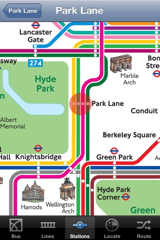
✔ Official map of London Bus. The map includes the key bus routes in central London, and provides all the best sights and attractions that the city has to offer. The main bus stations of central London are available. Landscape and portrait modes.
✔ Compatible with Retina Display on the iPhone 4 and iPhone 4S.
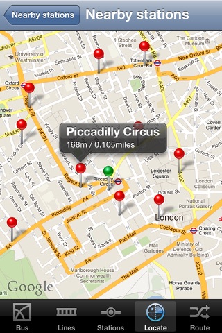
✔ Precise location of each station on the map (with a red circle). This application is fully compatible with Google Maps, each station is represented by a red pin, a popup shows you the distance, and its updated live (thanks to GPS) as you walk in the streets of London!
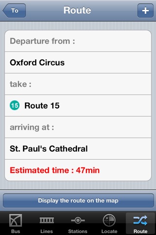
✔ The journey planner tool allows you to find automatically the best route to get to your destination. The journey planner does not require a network connection to operate.
✔ The bookmark manager allows you to save your favorite stations and routes.
✔ The application locates the nearest stations from your position in London. You can also provide an address in London, all the stations closest to that address will be displayed.
✔ London Tube is available in the same application through in-app purchase. This option allows you to switch between the bus and underground systems at any time using the same application. This add-on includes the official London Tube map from TfL, locates the nearest Tube stations, and also offers a Journey Planner tool.
✔ You can add new Point of Interest (POI) databases to London Bus application through in-app purchase. These options allow you to activate Food & Drink POI, Leisure POI, Attractions POI, and Accommodation POI in all over the UK. You will be able to locate all nearby POI on Google Maps, and through the Augmented Reality view.
************************************************************
AUGMENTED REALITY
************************************************************
London Bus Your New Eye. This is a unique augmented reality functionality that enables you to see the nearest stations and POI with iPhones camera live view. Elements located at a distance less than 1km (0,621miles) only will be displayed.
- iPhone vertical position: 360-degree view of all stations nearby your location, updated in real time as you walk in the streets.
- iPhone horizontal position: List of all nearest stations. When a station is selected, a red arrow (compass) is displayed to show the direction and the distance to that point.
IMPORTANT : This application requires an active Internet connection to retrieve data. You also need to turn on "Location Services" option in the settings of your iPhone.
Thank you for taking the time to report any bugs or to request an enhancement to London Bus Application. Feedback is very important to us. We will do our best to answer queries. Email us at [email protected]